Upper Mill Creek Canyon Road Improvements Project

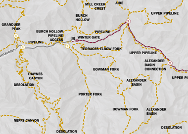
FHWA-CFLHD, in cooperation with Salt Lake County, Millcreek, and the Uinta-Wasatch-Cache National Forest (UWCNF) are proposing improvements to the upper 4.6 miles of Mill Creek Canyon Road, located primarily within the UWCNF in Salt Lake County, Utah.

The purpose of the project is to improve user safety, access to recreational opportunities for all users, and water quality degraded by surface erosion and poor drainage infrastructure. The project would extend from the Winter Gate parking area to the Upper Big Water Trailhead, where the road terminates.

Funding for the project is through the Federal Lands Access Program in conjunction with a local funding match.

Resources

What is FLAP?

Implement roadway safety and pedestrian crossing safety measures at high-frequency crossing areas like Elbow Fork Trailhead, such as signing, striping, and installing guardrails at appropriate locations.


Cost Estimate

To complete all the transportation improvements identified in Mill Creek Canyon, the cost estimate is $38,000,000. This FLAP project will cover the scope of work identified in the upper canyon only, between Big Water Trailhead and Winter Gate.


Total Project Value: $19,600,000


Local Required Match: $4,276,200

Upper Mill Creek Canyon Environmental Assessment and Draft Section 4(f) Evaluation

The Federal Highway Administration, Central Federal Lands Highway Division (FHWA-CFLHD) announces the availability for public review and comment of the Environmental Assessment (EA) and Draft Section 4(f) Evaluation for the Upper Mill Creek Canyon Road Improvement Project. The EA will be open for review for 30 days, from March 6 to April 5, 2024.

FHWA-CFLHD, in cooperation with Salt Lake County, Millcreek, and the Uinta-Wasatch-Cache National Forest (UWCNF), prepared the Upper Mill Creek Canyon Road Improvement Project EA, which examines the potential environmental impacts of the alternatives being considered for improvements to the upper 4.6 miles of Mill Creek Canyon Road, located primarily within the UWCNF in Salt Lake County, Utah. The project would extend from the Winter Gate parking area to the Upper Big Water Trailhead, where the road terminates. Funding for the project is through the Federal Lands Access Program in conjunction with a local funding match.

In compliance with the National Environmental Policy Act (NEPA), as amended, and applicable implementing regulations, FHWA-CFLHD has prepared an EA evaluating the project. Section 4(f) refers to the original section within the U.S. Department of Transportation Act of 1966 which provided for consideration of park and recreation lands, wildlife and waterfowl refuges, and historic sites during transportation project development. The draft Section 4(f) evaluation analyzes potential uses of and impacts to Section 4(f) properties within the project area and outlines measures to minimize harm to such properties.

The EA and Section 4(f) Evaluation can be obtained from the following website:

https://highways.dot.gov/federal-lands/projects/ut/flap-sla-10-1

To request a compact disc (CD) or hardcopy of the document, please send requests to millcreekcanyonroad@dot.gov.

To be considered in the decision-making process, written comments on the EA’s analysis and results of the environmental impacts of implementing the proposed action must be received by April 5, 2024. Please provide any written comments to Central Federal Lands Highway Division, 12300 W. Dakota Ave. Suite 380, Lakewood, Colorado 80228 or via email to millcreekcanyonroad@dot.gov.

The Forest Service will issue an independent decision on limited aspects of the project, as described in, and based on the analysis in the FHWA-CFLHD EA. The Forest Service decision is subject to 36 CFR 218 subparts A and B.  To be considered in the Forest Service decision-making process, written comments must be submitted to the Central Federal Lands Highway Division, as described above.

Persons with disabilities who require alternative means for communication of program information (braille, large print, audiotape, etc.) should make requests using the contact information above.

Public Open Houses

June 13th Virtual Open House

Due to technical issues, the virtual open house was presented to a limited audience. However, it was still run as planned and recorded so that the public would have access as quickly as possible. 

Watch the June 13th Virtual Open House

View the June 13th Virtual Open House Presentation Slides

June 14th, 2023 In-Person Open House

The Third Upper Mill Creek Canyon Road Improvement Project In-person Open House took place on June 14, 2023 from 5:30 - 7:30 PM MST at Millcreek City Hall, 3330 S 1300 E, Millcreek, UT at 5:30 PM.

Scroll Plot Maps of proposed Upper Mill Creek Canyon Road Improvements 

Winter Gate to Elbow Fork

Elbow Fork to Big Water


Mill Creek Canyon Road Improvements Project Public Comment Period is Now Closed

Public comments were accepted from June 4, 2023 to July 10, 2023 to be considered by the project partners and consultants during the remaining phases of the environmental review and preliminary design process.

Following an open house on Nov. 9, 2021, the project team received more than 340 comments from the public and reviewed them.

Comments focused on the importance of Mill Creek Canyon as a community resource, whether for its natural environment or recreation opportunities. Most comments fell into one or more major themes:

  • Resource protection
  • Bicycle and pedestrian safety
  • Increased speeds
  • Parking
  • Design element considerations
  • Shuttle system or other mass transit option
  • Level of environmental review
  • Firs cabin owner concerns
  • Section 4(f) evaluation

The project team is considering public input in the design and working to best balance often competing interests. The project team has compiled a summary of the public's comments and provided responses.

2023 Environmental Documents

The purpose of the Cultural Report, Biological Resource Report, and Other Resources Report is to share information with the public as part of the environmental process. Information contained in these reports is expected to be incorporated into an environmental assessment, which will also be made available for public review in the near future. Information presented on the affected environment in these reports is based on background research, field surveys, and coordination with other agencies.

This report presents an overview of the biological resources in the project area, anticipated resource issues associated with the proposed project, and FHWA-CFLHD’s approach to assess effects and ensure compliance with applicable regulations. Biological resources discussed include vegetation and vegetation communities, terrestrial and aquatic wildlife, U.S. Forest Service (USFS) and U.S. Fish and Wildlife Service (USFWS) special status species, and migratory birds. The project and this report incorporate the following regulatory framework:  

  • National Environmental Policy Act, which is an overarching regulation that requires federal agencies to consider the effects of their actions on the environment; 
  • 2003 Wasatch-Cache Revised Forest Plan (Forest Plan), which provides USFS guidance to manage resources, such as Sensitive species and riparian areas, on its lands; 
  • Endangered Species Act, which protects threatened and endangered species; and 
  • Migratory Bird Treaty Act, which protects migratory birds, their parts, and their nests. 

This report presents an overview of cultural resources, including archaeological and architectural resources, that could be affected by the proposed improvements and discusses FHWA-CFLHD’s approach to assess effects and ensure compliance with applicable regulations, such as the National Environmental Policy Act and National Historic Preservation Act (NHPA).

This report presents an overview of aquatic resources, land use, recreation and access, and visual resources, anticipated resource issues associated with the proposed project, and the Federal Highway Administration Central Federal Lands Highway Division’s approach to assess effects and ensure compliance with applicable regulations and plans such as the National Environmental Policy Act, the Clean Water Act, the 2003 Wasatch-Cache Revised Forest Plan (Forest Plan), and the Wasatch Canyons Master Plan and Wasatch Canyons General Plan Update.

Upper Mill Creek Road Improvements Timeline

2021 August-October Present scope of work, cost estimate, and timeline to local jurisdictions and partners
  Nov. 3 Press conference and start identifying sources for $4.3M match
  Nov. 9 Public Open House with FHWA Central Federal Lands Highway Division at Millcreek and
  Nov. 9 Start of 30-day public comment period
  Week of Dec. 6 Public comment period ends
2022 January - August Consider public comments, Preliminary Design, environmental field surveys, technical analysis
2023 May - December Pre-final design, final technical reports and NEPA documentation
2024 January - March Final Design, permitting, and contract preparation
  August - November Initiate construction. Prepare FLAP application for future phase: road improvements between Toll Booth and Winter Gate
2025 - 2026 Two seasons of construction

Construction is anticipated to take place during the available construction seasons in 2025 and 2026. During this time the road will be closed to vehicles and pedestrians.  

Major thru trails are anticipated to remain open with a road crossing at Elbow Fork. There will be a winter shutdown of construction activities allowing for ski grooming and pedestrian access on the roadway from mid-December to late-March.

2026 Summer Complete construction; ribbon cutting at Winter Gate

Project Scope

Big Water Trailhead to Elbow Fork (3.1 miles) with a 24’ wide paved surface Elbow Fork to Winter Gate (1.4 miles) with 29’ wide paved surface

Logo.

This may include Big Water Trailhead, Alexander Basin Trailhead, Clover Springs Picnic Area, Fir Crest Picnic Area, and Elbow Fork Trailhead. The Winter Gate Parking/Trailhead will be designed for a future phase.

Icon.

Improve watershed functioning at Thousand Springs. The road through this section will be widened and the streambed channel will be realigned to address safety issues.

Logo.

Extend recently installed box culverts, add headwalls and wingwalls to improve roadway safety. We will consult with the State Historic Preservation Board to address concerns with the historic White Bridge.

Icon.

Install a 2-inch diameter conduit within the shoulder of the road to support future monitoring (Intelligent Transportation Systems/Dynamic Message Signs) and emergency communications in the canyon.

Icon.

Implement roadway safety and pedestrian crossing safety measures at high-frequency crossing areas like Elbow Fork Trailhead, such as signing, striping, and installing guardrails at appropriate locations.

Logo, company name.

Contact Us

If you have any questions or feedback please email hpeters@slco.org or drodgers@slco.org.

Subscribe to the Upper Mill Creek Canyon Road Improvements Project Email List

* indicates required