
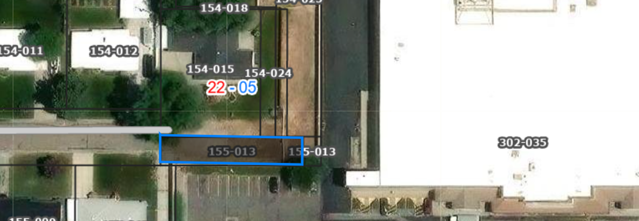
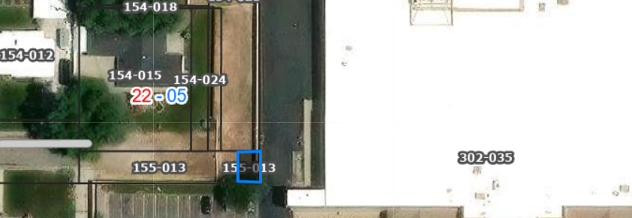
Surplus Real Property for Public Sale

The Salt Lake County Real Estate Division is responsible for disposing of surplus real property owned by the County. If you are interested in purchasing any of the real properties listed below, please email your offer to Mr. Clinton Benson, Real Estate Operations Manager.

All properties will be sold at fair market value to the party making the highest offer above the minimum price listed with the property. The listed sales price does not include certain cost such as, but not limited to, cost of appraisal, filling fees, and administrative fees, which are the buyer's responsibility. If you need additional information regarding these fees, please email Mr. Benson.

Properties with a value of over Two Hundred Fifty Thousand Dollars ($250,000.00) will require a public hearing. Moreover, for all real property sales the County and the buyer must enter into a written purchase and sale agreement ("PSA"), which must be approved by the Salt Lake County Council, and signed by the Salt Lake County Mayor, and the Salt Lake County Clerk before the PSA becomes binding and a sale of the real property can be finalized.

The County makes no warranties or representations as to whether Properties are buildable or developable, nor does the County make any representations regarding whether the Properties comply with applicable zoning regulations. The County does not warrant or represent that the Properties are habitable or in any particular condition. The County also makes no warranties or representations regarding the accuracy of the assessment of the Properties or the accuracy of the description of the real estate or improvements therein.

Available Parcels

8562011 i57-010 . 3011013' 301-011 156018 ısı-oıı 156-019 156020 156-021' 156-031 326-002 302-033 2-034 326-001 001 326-018 326-019 316-010
  • Parcel #: 22-02-157-014-0000
  • Total Acreage: 0.29
  • Tax District: 82
  • Tax District Location: HOLLADAY/G
  • Legal Description: BEG N 117.88 FT & E 530.19 FT & S 40 FT M OR L & S 86^57'53"E 458.73 FT M OR L FR W 1/4 COR SEC 2, T2S, R1E, SLM; S 86^57'53" E 336.52 FT M OR L; S 7.95 FT M OR L; S 88^26' W 177.55 FT; S 64^58' W 175 FT M OR L; N 104.67 FT M OR L TO BEG.
  • Minimum Price: $385,000
  • Offer Close Date: Monday, May 4, 2026

A bird's eye view of a city.
  • Parcel #: 33-10-451-016-0000
  • Total Acreage: 1.78
  • Tax District: 45
  • Tax District Location: BLUFF/J
  • Legal Description: BEG N 377.165 FT & E 236.861 FT FR S 1/4 COR SEC 10 T 4S R 1W, S L M; N 28^40' W 79.06 FT; N 02^54'59" W 103.4 FT; N 23^40' W 18.47 FT; N 89^28'14" E 422.97 FT; S 02^57' 25" W 26.13 FT; S 03^55'35" E 149.56 FT; S 12^34'19.2" W 15.024 FTM OR L; S 89^28'14" W 377.99 FT TO BEG. LESS CANALS 1.784 ACM OR L. 6170-2188 7194-0570
  • Minimum Price: $590,000
  • Offer Close Date: Monday, May 4, 2026

1J6•oo• 7.126-026 1*6-075 126-009 cot 8 av 103003 10+00', 103-000 1>6-011 126-01 126-015
  • Parcel #: 14-34-126-010-0000
  • Total Acreage: 0.19
  • Tax District: 29
  • Tax District Location: WVC/G
  • Legal Description: LOT 66, COPPER HILL HEIGHTS #11
  • Minimum Price: $187,000
  • Offer Close Date: Monday, May 4, 2026

1532022S, 153-059 154-004 153-058 154-005 1 54-02 154-018 154-015 154-020 176-008 302-035 011 5-009 01) 155-013 155-013
  • Parcel #: 22-05-154-025-0000
  • Total Acreage: 0.18
  • Tax District: ACN
  • Tax District Location: MILLCREEK/G
  • Legal Description:  BEG 582.17 FT N 0^05'44" E & 641.01 FT S 89^54'15" W FR SE COR OF LOT 1, BLK 5, TEN ACRE PLAT A, BIG FIELD SUR; S 0^09'58" W 228.57 FT; S 89^54'14" W 30 FT; N 0^09'58" E 112.77 FT; S 89^54'14" W 10.01 FT; N 0^09' 58" E 115.8 FT; N89^54'14" E 40.01 FT TO BEG. 0.18 AC 5783-2081, 5789-549
  • Minimum Price: $63,000
  • Offer Close Date: June 8, 2026 

154-004 154-005 154Z025 154-018 54-011 55-010 1 64 0 1 ' 154-015 154-024 302-035 1 bH)13 155-017 013
  • Parcel #: 22-05-155-013-4001
  • Total Acreage: 0.07
  • Tax District: ACN 
  • Tax District Location: MILLCREEK/G 
  • Legal Description:  BEG NE COR LOT 9, LADORE SUB; S 89^46'10" E 142.4 FT; N 0^ 09'59" E 26.19 FT; S 89^54'14" W 142.43 FT; S 0^05'30" W 25.37 FT TO BEG. LESS THAT PORTION OUTSIDE S L COUNTY WATER CONS DIST. 0.072 AC M OR L.
  • Minimum Price: $25,000
    Offer Close Date: June 8, 2026 

-004 154-005 154Z025 154-018 154-015 154-024 302-035 155-013 155-017
  • Parcel #:  22-05-155-013-4002
  • Total Acreage: 0.01
  • Tax District: ACP
  • Tax District Location: MILLCREEK/G
  • Legal Description: BEG NE COR LOT 9, LADORE SUB; S 89^46'10" E 142.4 FT; N 0^ 09'59" E 26.19 FT; S 89^54'14" W 142.43 FT; S 0^05'30" W 25.37 FT TO BEG. LESS THAT PORTION INSIDE S L COUNTY WATER CONS DIST. 0.008 AC M OR L.
  • Minimum Price: $2,800
  • Offer Close Date: June 8, 2026